
The mountain’s displacement towards the sea caused the second highest tsunami ever recorded, after the 2011 tsunami in Japan. This event had an impact equivalent to a 5.4 magnitude earthquake and caused seawater to rise up to 481 meters on the wall of the Tracy Arm Fjord where it occurred.
A team of scientists published a study in the journal Science describing the event in question and the lessons to be learned from it. The main message of the study is that such events need to be given much more attention; Because as global warming causes glaciers to retreat, these events will occur more and more frequently, especially in polar and subpolar regions.
Dan Shugar, a researcher at the University of Calgary in Canada and one of the authors of the study, says, “The risk of tsunamis increases as cold regions of the planet warm, and it is urgent to develop better monitoring systems for these events. The aim of our paper is to ensure that coastal municipalities and other interested parties take these threats seriously.”
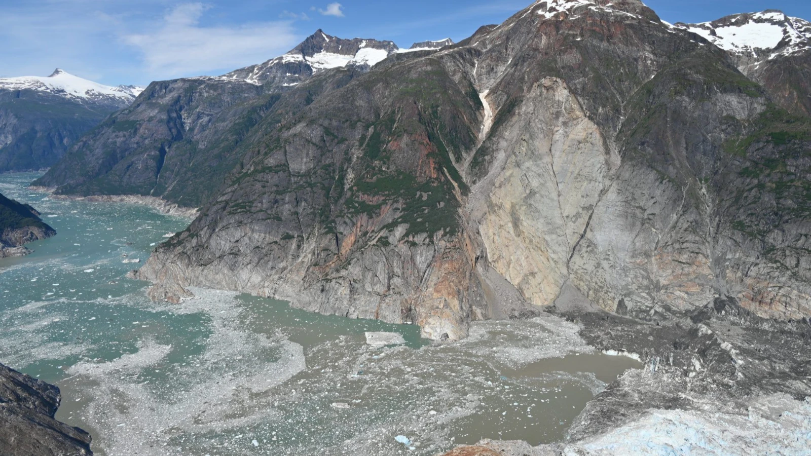
The horrifying details of the 481-meter tsunami that occurred in the Tracy Arm Fjord, about 80 kilometers south of the city of Juneau, on the southeast coast of Alaska on the morning of August 10, 2025, have been revealed.
At that hour, a huge wedge-shaped mass of rock at the top of the South Sawyer Glacier collapsed. This collapse released tens of millions of cubic meters of material. The mass of rocks and debris hit the area where the glacier meets the sea, displacing large amounts of ice and water and creating a tsunami.
Melting glaciers in the Tongass National Forest, considered one of the “lungs” of the planet, is drawing more and more tourists to the area. According to researchers, approximately 20 cruise ships travel through the region every day, especially during the summer months. In addition, tour boats and skiers also frequently visit the fjord.
Despite this, the giant wave did not catch anyone. Because the incident occurred almost at dawn, and at that time neither boats nor travelers had yet entered the waters of the fjord.
scientific reconstruction
Researchers reconstructed the event using satellite data, seismic information, numerical models and eyewitness accounts. Satellite data was used to compare the situation before and after the event.
Members of a group of skiers camping on land said that when they woke up around 05.45 in the morning, the water had reached their tents, dragging their skis and some belongings away. People on a cruise ship anchored near the mouth of the fjord observed strong currents and foaming.
The combined analysis revealed that the hillside gave few visible warning signs before collapsing. However, there were seismic signals indicating increased instability in the days before the collapse and especially in the final hours.
The landslide itself produced seismic waves equivalent to a 5.4 magnitude earthquake, and these waves could be detected around the world.
According to researchers, the collapse occurred due to the retreat and thinning of the glacier. The shrinking of the glacier removed the structural support that supported the hillside, and the hillside became increasingly fragile.
As the tsunami moved through the fjord, it stripped vegetation from the steep walls. Thus, a distinct high-water mark was formed, reaching 481 meters above sea level.
Beyond the initial wave, the event also triggered water releases within the fjord that lasted for hours or even days. This phenomenon, known as Seiche, could be detected in both seismic and satellite data.
Lessons learned
According to the researchers, this long-lasting resonance of the fjord, a kind of “hum”, and the seismic activity that precedes the landslide offer potential new tools for identifying and monitoring landslide-induced tsunamis in remote areas.
“As glaciers retreat, permafrost thaws, and human activity intensifies in the Arctic and Subarctic regions, the likelihood of such events increases, highlighting the urgent need for improvements in identifying and mitigating risks,” says Shugar.
The authors also remind us that in 2026, at least six cruise lines have changed Alaska itineraries because of the dangers that still exist in the Tracy Arm fjord. The US Geological Survey has also warned about the danger of mountain landslides in these regions on its website.